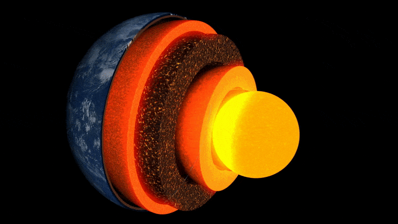
Animasi lapisan bumi.
Penelitian baru yang dipimpin oleh University of Cambridge adalah yang pertama mendapatkan ‘gambar’ rinci dari kantong batu yang tidak biasa di antarmuka inti bumi, sekitar dua ribu mil di bawah permukaan.
Daerah berbatu misterius, yang terletak hampir tepat di bawah Kepulauan Hawaii, adalah salah satu dari beberapa zona berkecepatan sangat rendah — dinamakan demikian karena gelombang gempa melambat saat melintas.
Penelitian ini dipublikasikan dalam jurnal pada 19 Mei 2022 komunikasi alamadalah yang pertama mengungkapkan secara rinci variabilitas internal yang kompleks dari salah satu kantong ini, dan menyoroti lanskap interior yang dalam dan proses yang terjadi di dalamnya.
“Dari semua fitur interior terdalam bumi, ini adalah yang paling menarik dan kompleks.” – Zhi Li
“Dari semua fitur bagian dalam Bumi, ini adalah yang paling menarik dan kompleks. Kami sekarang memiliki bukti kuat pertama dari struktur internal mereka – ini adalah tonggak nyata dalam seismologi Bumi dalam,” kata penulis utama Zhi Li, seorang mahasiswa PhD di Departemen Ilmu Bumi di Cambridge.
Bagian dalam bumi berlapis seperti bawang: di tengahnya terdapat inti besi-nikel, dikelilingi oleh lapisan tebal yang disebut mantel, dan di atasnya ada lapisan luar yang tipis – kerak tempat kita hidup. Meskipun mantelnya adalah batuan padat, ia cukup panas untuk mengalir dengan sangat lambat. Arus konveksi internal ini menambah panas ke permukaan, mendorong pergerakan lempeng tektonik, dan memicu letusan gunung berapi.
Para ilmuwan menggunakan gelombang seismik dari gempa bumi untuk “melihat” di bawah permukaan bumi – gema dan bayangan gelombang ini mengungkapkan gambar seperti radar dari topografi interior dalam. Namun hingga baru-baru ini, “gambar” struktur pada batas inti-mantel, area yang menjadi perhatian utama untuk mempelajari aliran panas internal planet kita, telah buram dan sulit untuk ditafsirkan.
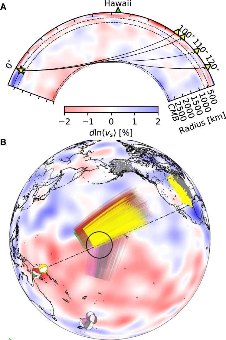
Peristiwa dan jalur sinar Sdiff yang digunakan dalam penelitian ini. A) Penampang melintang melalui pusat zona kecepatan ultra-rendah Hawaii yang menunjukkan jalur sinar gelombang Sdiff pada 96°, 100°, 110°, dan 120° untuk model Bumi PREM 1D. Garis putus-putus dari atas ke bawah menandai diskontinuitas pada 410 km, 660 km dan 2791 km (100 km di atas batas inti-mantel). B) Peristiwa dan sinar Sdiff pada model tomografi latar belakang SEMUCB_WM1 pada kedalaman 2791 km. Acara bola pantai ditampilkan dalam berbagai warna termasuk 20100320 (kuning), 20111214 (hijau), 20120417 (merah), 20180910 (ungu), 20180518 (coklat), 20181030 (merah muda), 20161122 (abu-abu), stasiun (segitiga ) dan sinar lintasan gelombang Sdiff pada kedalaman penetrasi 2791 km pada mantel terendah yang digunakan dalam penelitian ini. Peristiwa yang digunakan dalam analisis jangka pendek disorot dengan warna kuning. Lokasi ULVZ yang diusulkan ditampilkan dalam lingkaran hitam. Garis putus-putus menunjukkan penampang yang diplot di A. Kredit: Komunikasi Alam, DOI: 10.1038/s41467-022-30502-5
Para peneliti menggunakan metode pemodelan numerik terbaru untuk mengungkapkan struktur skala kilometer di antarmuka inti-mantel. Menurut rekan penulis Dr. Kuangdai Leng, yang mengembangkan metode selama waktunya di[{” attribute=””>University of Oxford, “We are really pushing the limits of modern high-performance computing for elastodynamic simulations, taking advantage of wave symmetries unnoticed or unused before.” Leng, who is currently based at the Science and Technology Facilities Council, says that this means they can improve the resolution of the images by an order of magnitude compared to previous work.
The researchers observed a 40% reduction in the speed of seismic waves traveling at the base of the ultra-low velocity zone beneath Hawaii. This supports existing proposals that the zone contains much more iron than the surrounding rocks – meaning it is denser and more sluggish. “It’s possible that this iron-rich material is a remnant of ancient rocks from Earth’s early history or even that iron might be leaking from the core by an unknown means,” said project lead Dr Sanne Cottaar from Cambridge Earth Sciences.

Conceptual cartoons of the Hawaiian ultra-low velocity zone (ULVZ) structure. A) ULVZ on the core–mantle boundary at the base of the Hawaiian plume (height is not to scale). B) a zoom in of the modeled ULVZ structure, showing interpreted trapped postcursor waves (note that the waves analyzed have horizontal displacement). Credit: Nature Communications, DOI: 10.1038/s41467-022-30502-5
The research could also help scientists understand what sits beneath and gives rise to volcanic chains like the Hawaiian Islands. Scientists have started to notice a correlation between the location of the descriptively-named hotspot volcanoes, which include Hawaii and Iceland, and the ultra-low velocity zones at the base of the mantle. The origin of hotspot volcanoes has been debated, but the most popular theory suggests that plume-like structures bring hot mantle material all the way from the core-mantle boundary to the surface.
With images of the ultra-low velocity zone beneath Hawaii now in hand, the team can also gather rare physical evidence from what is likely the root of the plume feeding Hawaii. Their observation of dense, iron-rich rock beneath Hawaii would support surface observations. “Basalts erupting from Hawaii have anomalous isotope signatures which could either point to either an early-Earth origin or core leaking, it means some of this dense material piled up at the base must be dragged to the surface,” said Cottaar.
More of the core-mantle boundary now needs to be imaged to understand if all surface hotspots have a pocket of dense material at the base. Where and how the core-mantle boundary can be targeted does depend on where earthquakes occur, and where seismometers are installed to record the waves.
The team’s observations add to a growing body of evidence that Earth’s deep interior is just as variable as its surface. “These low-velocity zones are one of the most intricate features we see at extreme depths – if we expand our search, we are likely to see ever-increasing levels of complexity, both structural and chemical, at the core-mantle boundary,” said Li.
They now plan to apply their techniques to enhance the resolution of imaging of other pockets at the core-mantle boundary, as well as mapping new zones. Eventually, they hope to map the geological landscape across the core-mantle boundary and understand its relationship with the dynamics and evolutionary history of our planet.
Reference: “Kilometer-scale structure on the core–mantle boundary near Hawaii” by Zhi Li, Kuangdai Leng, Jennifer Jenkins and Sanne Cottaar, 19 May 2022, Nature Communications.
DOI: 10.1038/s41467-022-30502-5

“Ninja twitter bersertifikat. Ahli internet. Penggemar budaya pop hardcore. Baconaholic.”
You may also like
-
Aturan matematika ditemukan di balik distribusi neuron di otak kita
-
Para ilmuwan menemukan penjelasan untuk lubang gravitasi raksasa di Samudra Hindia
-
Peta baru yang akurat dari semua materi di alam semesta dirilis
-
Para ilmuwan mengatakan sepasang bintang yang sangat langka berperilaku sangat ‘aneh’
-
Lima Angsa Tewas Setelah Terbang Ke Saluran Listrik Hinkley | Berita Inggris